
In a series of presentations and podcasts over the past year, Stamen cartographers Alan McConchie and Stephanie May have been exploring the world of contemporary online map making, and how Stamen Design has developed a uniquely collaborative way of working to build maps for a wide range of clients. In this short recorded conversation, we asked Alan and Stephanie to summarize their thoughts on the new cartographic landscape, and explain what the phrase “Full Stack Cartography” means to them.
Audio:
Transcript:
Alan: What is “Full Stack Cartography”? It’s something we’ve been thinking about a lot at Stamen in the last couple of years. Hi, I’m Alan, Lead Cartographer at Stamen Design.
Stephanie: Hi, I’m Stephanie, Director of Geospatial at Stamen. Here are some of the ways we’ve talked about Full Stack Cartography in public recently.
First I’d like to credit Katie Kowalsky who first put this concept in our ears, and also Gretchen Peterson who introduced the idea in her book “GIS Cartography: A Guide to Effective Map Design”.
Alan, what do you think Full Stack Cartography is?
A: Well that’s a good question! Recently I was on the MapScaping Podcast, interviewed by Daniel O’Donohue, and we had a deep dive into the subtle details of how Stamen Design thinks about our work making global maps for a variety of clients and use cases. As we discussed what makes Stamen’s work unique and challenging–but also ultimately uniquely rewarding–we kept coming back to this concept of “Full Stack Cartography”.
For me, this concept emphasizes a way of working in which the final design decisions we make on a map (for example, what should the roads look like) requires knowledge and involvement with all the preceding steps, such as data collection and cleaning, geometry simplification, tiling, and so on. There are plenty of available solutions out there where some or all of these phases are taken care of for you, but if you really want the most efficient solution that is perfectly tailored to a specific use case (which is our specialty at Stamen) you need to customize the stack at every step.
S: For me, the term “Full Stack Cartography” resonates slightly differently. For much the same reason you might hire a full stack engineer, full stack cartographers can integrate their workflows within the parallel processes of engineering and rendering, designing, and building a map, and they can do it all at scale, in the cloud, so that the work fits at the core of developing a modern mapping application or platform, instead of somewhere off to the side.
A: Exactly, and this cartographic journey through the “full stack” of development with data, rendering, and all these associated processes is rarely a straight line. It’s a bit more of a twisting, forking path through a lot of potential alternatives and decision points that are informed by design, engineering, and end user or product considerations.
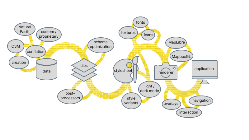
S: Totally Alan! When you say it that way, I remember that when we were preparing for the NACIS presentation I did recently “What is Vector Tile Cartography?” we worked out this Frankenstein metaphor, describing this cross between the Yellow Brick Road and a garden of forking paths. Every choice has its pros and cons, and comes with knock-on effects further down the stack, which is very in keeping with our experience as cartographers. By keeping the ultimate goal in mind–the ideal solution for a specific use case–we can make the best decisions at each step along the way.
A: I find it helps to have some concrete examples when talking about this. So on that Mapscaping Podcast, Daniel and I were really grounding our discussion in a very specific use case: a hypothetical custom basemap for a mountain biking app. Supposing someone hired Stamen to make such a map, Daniel and I went through every step in the process, from data collection all the way to the end-user’s mobile device, talking about all the decisions we’d need to make along the way: where do we get the data from; what attributes does the data need, such as whether a trail is dirt or gravel, or do we need to know if it’s public or private; what other features on the map to include as necessary context for mountain bikers or what features we want to remove to avoid any distraction. We could spend a lot of time talking about specifics here, but I encourage you all to go listen to that podcast to go into more detail.
S: So yes, definitely go listen to that podcast, and let me just throw out another whackadoo analogy out there. What if mountain biking and iterative design of maps are similar? You should be able to see the changes you’re making iteratively at a glance with one side of your eye with all the other things that are going on in your mind when you’re navigating. That’s the kind of objective that we have when designing our tooling workflows. Even when the underlying data is quite complex, the end result should communicate a simple and direct visualization of what we need to see, and just glancing at it should tell you if you’ve gotten it right. The way we do iterative design and also and use peer review, so that we’re working in our favorite way which is collaboratively, we can communicate our cartographic decisions in a very ordered, structured data sort of way, which software engineers really appreciate.
A: And that point about it being collaborative is super important. That was one of the things I really liked in that podcast interview you did with Ross, is that it’s really impossible for one person to be an expert in every part of the stack. Unlike mountain biking, it is a team effort, and it’s intensely collaborative. And it doesn’t just happen without building systems and tools like Figmasset to make this collaboration work smoothly.
Also in the podcast there’s so much other good stuff. I really like how you talked a lot about your background, and your interdisciplinary studies in your schooling and how all of that shaped your thoughts on Full Stack Cartography today. It brought together a lot of the themes I’ve been hearing from you over the years we’ve worked together, and gave me a chance to think about how much we’ve influenced each other’s thinking, talking about concepts like Full Stack Cartography.
S: I loved your Mapscaping podcast too, Alan! Let’s not forget to mention that you also talked about a bunch of interesting related topics, such as “what’s a ‘basemap’” and “how do map tiles work” and “what does the future hold for cartography”? Daniel has an excellent summary of the episode on his blog, and please everyone give it a listen and let us know what you think!
A: Yeah, go listen to the MapScaping podcast, go read the summary on that blog, and also check out Pollinate, which is our Stamen podcast. The latest episode features Stephanie’s takes on Full Stack Cartography as an interdisciplinary exercise, and also we have a blog post about it with a full transcript. So check out Pollinate on whatever streaming services you get your podcasts. And, stay tuned, because our next episode is coming where I interview Tanya Ruka from Native Land Digital about indigenous mapping. I’m very excited about that one too!
- Alan McConchie on Pollinate talking about basemaps on “The Maps Underneath” (blog / podcast)
- Stephanie May’s presentation at NACIS “What is Vector Tile Cartography?” (video)
- Alan McConchie on MapScaping discussing about “Full Stack Cartography” (blog / podcast)
- Stephanie May on Pollinate talking about “Interdisciplinary Cartography” (blog / podcast)