
Digital maps are everywhere. Through real-time data feeds and integrations, maps can turn into comprehensive multi-purpose tools within your organization, as well as a core part of operations, logistics, and customer-facing products. Geospatial analysis and location intelligence is a business priority for all industries, including governmental agencies, non-profit organizations, telecommunications groups, manufacturing and retail. At the same time, maps are ubiquitous in our daily lives — we use them to drive, shop, make travel plans, explore nature, track deliveries, and transmit our location from devices we carry around with us everywhere we go.
Of course, as powerful as the domain of mapping is, it is also complex. The right tool for habitat restoration and ecological research has almost nothing in common with the right tool for critical business insights about resource management or consumer purchase patterns, except that they are both maps. Maps can reveal where your friends are, track election results, identify vulnerable bird populations.
Maps are uniquely compelling and intuitive on a subconscious and emotional level. We feel a special attachment and familiarity with maps of where we live, and of the whole world, and we absorb information from them more quickly and easily than in almost any form. We take them for granted, we depend on them, and they give structure, meaning, and aesthetic beauty to our everyday lives. At Stamen we stake our livelihood on the belief that as with any product, maps work best when form follows function, and they are designed well.
Knowledge Limitations Can Curb Possibility
The tools used to make maps today are vastly different from those used in the past. You may have a GIS expert in your organization who can run complex environmental modeling or site selection algorithms. However, they won’t have the technical expertise needed to do the data science, back-end and front-end development required to build a mapping application suitable for bringing community stakeholders or company executives along when making data-driven decisions. Making an application that is mobile-friendly, accessible, performant, scalable, extensible, and updatable is unrealistic, to say the least.
Your product manager may have vision, communication skills, and a knack for analysis and strategy. But chances are, they have even less digital mapping technical experience. While they are likely the closest to your customers and have the necessary business sense, project managers typically don’t have the skillset to scale a digital map to meet your organization’s unique needs.
Your product managers, of course, work closely with your engineering team. And, while your engineering team is excellent at their work, most don’t have extensive experience handling large geographic datasets or pipelines. Maintaining the integrity and usability of geographic data requires specialized software libraries, toolsets and domain knowledge.
Similarly, your designers may be well-versed in interactive UI and UX design. Still, the interactive elements of digital maps are incredibly different from the interactive design elements of a standard web page or form. Without a thorough understanding of the technology that supports digital mapping, many designers cannot apply their firm’s branding experience without breaking functionality or code.
You Need Digital Cartography Expertise — With a Design Focus
Maps have always been both a technical and a design challenge. As more organizations recognize the incredible business value location awareness, literacy, and interactivity bring to internal and customer-facing applications, they realize the need to invest in maps as part of their organizational infrastructure.
Despite the power and functionality of each of these tools, it is easy to invest money and time in complex ecosystems with nothing to show for it.
Given the marketplace for mapping products, platforms and services, many organizations struggle with where to invest. There are myriad options available — from tools like ArcGIS and QGIS, to coding libraries in Python or R, to web mapping libraries like Leaflet, MapLibre, OpenLayers, or D3, to location services platforms like Mapbox, Google Maps, Amazon Location Services, or Cesium. And don’t forget geospatial analysis platforms like CARTO or Kepler.gl. Despite the power and functionality of each of these tools, it is easy to invest money and time in complex ecosystems with nothing to show for it.
To bring your mapping vision together, first understand the fundamental difference between spatial analysis and cartographic display. The former is for those seeking insights from raw or emergent data. The latter is for showcasing those insights, or any other spatial signal, without the noise of everything else that will distract from the story you need to tell. You may need both within your organization or at different stages in your product development. But if your purpose is cartographic display, you should expect to use different tools than you would for spatial analysis — ones that are built for the modern web rather than for rapidly iterating through data transformation and computations.
The next difference you need to consider is whether the map you are creating is fundamentally about location at the human or individual scale of streets or buildings or trees or other physical features, or rather about showing aggregate trends, regional variations, change over time, or other themes. Your map can contain both elements, but it is difficult to make a map that simultaneously does both of these things well. You have to pick which one is more important.
This distinction between a street-level or reference-based map and an aggregate trend or thematic map will be familiar to any trained cartographer, but is less commonly understood in the digital mapping space where so much has been pioneered by Google. However, even if a full-featured mapping platform turns out to be exactly what you need, you won’t regret the time you spend understanding this distinction. This is because framing mapping projects as cartographic problems will lead you to better cartographic solutions.
Mapping Service Platform
“But I know exactly what I want,” you may be saying by now. “My organization needs something like Google Maps that shows me street level data when I zoom in, and country level data when I zoom out, and I can search for everything and route to where I need to go!”
If you are not focused on analytics, but rather logistics, location, or infrastructure, then you may be right — that may be exactly what you need, and you have a host of options.
Off-the-shelf digital mapping platforms like Mapbox, Google Maps or Amazon Location Services provide you with reference layers or basemap options with different levels of customization for function and styling. They also provide other ancillary services that might be incredibly valuable for your product or operations use case, like access to a database of points of interest (POIs) or places, and the ability to search or geocode (transform between a place or address and a point location on a map) and route or navigate via turn-by-turn directions.
Pros:
These services offer an accessible avenue for beginning to work with digital, interactive maps. Most are customizable and can be used to support your app or product.
Cons:
If your map will experience heavy usage, a mapping service platform can quickly become an expensive line item on your budget and is subject to slow rendering and faulty critical paths. As with any third-party application, the service is also more decentralized from your operation, and it can take the platform’s team time to dig into your particular help request. Similarly, users are inherently subject to the platform’s routine maintenance downtimes, bug fixes, and crashes. Further, while these platforms typically have robust security protocols, data breaches still can happen. Hosting and sharing sensitive data to any external cloud service may be inappropriate.
Finally, while a mapping service platform addresses some gaps in cross-functional and technical expertise among in-house designers, GIS experts, product owners, and engineers, your team must still come together to establish and create their own workflows to feed into the platform’s mapmaking process.
Full-Stack Cartography Consultation
Full-stack cartography, a concept we recently discussed in this 7-minute conversation, brings cartographic expertise to the entire process of digital mapping in-house for your project. This approach saves time and money by taking into consideration your organization’s entire workflow — and each role that touches it — and working with you to design the right solution.
This approach saves time and money by taking into consideration your organization’s entire workflow — and each role that touches it — and working with you to design the right solution.
This holistic process connects the functionality of your engineers, design team, product owners, and GIS experts with a team of digital cartographers and data visualization artists to incorporate design thinking into the map-making process. A full-stack cartography approach is agnostic to which mapping solutions you are considering or already using — whether it’s Esri, Mapbox, Google, or other mapping stacks. There are a variety of solutions or combinations of solutions that will work best for your use cases and your budget. It may include any existing geospatial mapping library, platform or tool, or we may recommend a custom workflow or technology stack your organization can build and own.
Many of our customers are intrigued by the possibility of building their own version of Mapbox or Google Maps. While it isn’t the right solution for everyone, Kevin Schaul, senior graphics reporter, recently explained why it’s the right solution for the Washington Post. Once you know what you need from display maps in your organization, creating that capacity in-house can be a smart move.
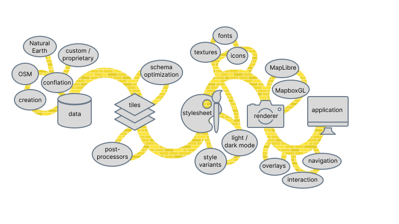
The tortured metaphor we have used to describe building your own zoomable, clickable, searchable mapping solution is that it’s like following a forking yellow brick road. There are decisions at every turn, and once you’ve started exploring those side paths, it’s pretty easy to wind up at a level of complexity that requires software engineers, visual designers, data experts to support, and technical cartographers who can communicate with all the various team members.
When you work with a consultative full-stack cartography firm, every decision at each stage of your internal workflow will make your map the best product it can be for your particular use case.
Pros:
A digital map perfectly tailored to your specific use case requires customization at every development step: from data collection and cleaning to geometry simplification to tiling and beyond. Full-stack cartographers can help you integrate your workflows within the parallel processes of engineering, rendering, designing, and building a map. As they consult with you directly, your teams problem-solve together to account for every design, engineering, consumer, and product decision point, iterating until you reach the best map product. Your map will be hosted in-house, where you have complete quality and security oversight.
Cons:
Full-stack cartography consulting will add to the up-front cost of your project, and may not make sense if your project fits squarely within the service offerings and cost modeling of an existing solution, or if your use case fits squarely in the domain of your staff.
Choosing Your Right-Fit Cartography Strategy
Confident answers to a few simple questions will help you determine which mapping strategy is right for you (and can save you money, too).
- Can my organization self-host a web platform with a front and back end?
- Is my map data used and maintained internally within my team or organization?
- Is my map data sensitive or proprietary?
- Do my clients, customers, or stakeholders need to explore the map across many geographies and scales?
- Am I isolated in my department and struggling to connect the dots for map-building across my organizational structure?
If you need to show more straightforward layers like roads or location names on your map and don’t need to customize these things beyond their current availability in open-source data, then a one-stop-shop mapping platform may be your best bet. However, if you need your viewers to be able to display your custom data at different scales and across diverse geographies, the ability to self-host your map, custom vector tile cartography, or assistance building cross-functional data pipelines and workflows, you likely need a full-stack cartography consultation team.
The art and science of digital map-making continues to require more and more collaboration in cross-disciplinary work. Such collaboration is essential to innovation and opens the doors to clever mapping solutions that even your most competent design, technical, or data analytics expert may not consider or be able to accomplish on their own.
Spending the time to truly understand the business objectives you want your map to meet sets you up for success. And, if you are still unsure about how to best tackle your digital mapping challenge, you can contact full-stack cartography experts for guidance.